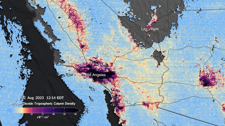
NASA shared the first data maps produced by Tropospheric Emissions: Monitoring of Pollution (TEMPO), a space instrument that can map out air pollutants over North America.

Read Also : NASA's Juno Delivers Sharper Images of Io
TEMPO's First Images
While it is no surprise that lively and big cities are major contributors to pollution, TEMPO was able to capture the daily evolution of nitrogen oxide concentration of Los Angeles, New York, Las Vegas, Washington, and New Orleans. Nitro oxide is a by-product of fossil fuel combustion which can lead to damaging effects to humans' respiratory system. However, nitrogen oxide is only one of the many toxic pollutants that TEMPO was able to detect.
"It measures ozone, nitrogen dioxide, formaldehyde, aerosols, water vapor, and several trace gases. There are already almost 50 science studies being planned that are based around this new way to collect data," TEMPO principal investigator Kelly Chance explained.
In addition, TEMPO was able to provide deeper understanding on how daily things such as rush-hour traffic, smoke movement, forest fires, fertilization, and more are contributing to pollution.
TEMPO's Launch to Space
The instrument was launched last April and has been making hourly daytime scans of the lower atmosphere of North America starting from Atlantic Ocean to Pacific Coast.
TEMPO is a science mission of NASA in partnership with the Smithsonian Astrophysical Observatory (SAO) in Cambridge, Massachusetts which aims to detect and measure pollution that are normally hard to come-by within reflected sunlight.
"We look forward to completing commissioning of the instrument and then starting science research," TEMPO project manager Kevin Daugherty shared.
Related Article : NASA Logs July 2023 as Hottest Month Since 1880


